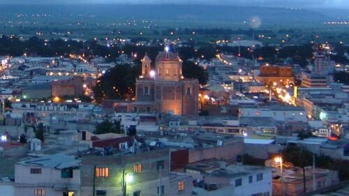
Info about Tulancingo, Estado de Hidalgo (Mexico)
Tulancingo is a district in Estado de Hidalgo, with country Mexico (MX).
Tulancingo names are also Tulancingo, Tulancingo de Bravo, its latitude is 20.0835500, and longitude is -98.3628800.
With a population of 161.069 citizens, this area timezone is America/Mexico_City (America/Mexico_City_cet).
In your trip to Tulancingo you can do parachute in Mexico.
.
More details about Tulancingo in Mexico (MX)
It is the capital of Tulancingo.
It has timezone UTC−06:00 (in standard time).
In Tulancingo live 161.069 citizens, according to 2015 census.
Its size is 217 km2, good if you like to visit a mid-sized city, in our opinion a place worth visiting. If you stay in this town you can save money because of its cheap housing rates, and this is why you can have it like basecamp if you want to move across Mexico and Tulancingo near places.
Tulancingo elevation above mean sea level, technically meters above mean sea level (MAMSL), is under 2157 meters. That is why this city is an ideal destination if you and your partner love high areas to see in your next travel and love adventure in the nature while you are travelling abroad.
Cities near Tulancingo that you can visit are cities like Acaxochitlán (municipality). As those cities are near Tulancingo you and your companions could easily reach these close wonderful destinations to see other destinations in Mexico.
If you’re looking for extra information about this city see their official website http://www.tulancingo.gob.mx.
Tulancingo things to do and activities: best trip destination for:
Interactive Tulancingo (Mexico) Map and attractions
Interactive map of Tulancingo, Estado de Hidalgo Mexico (MX).
