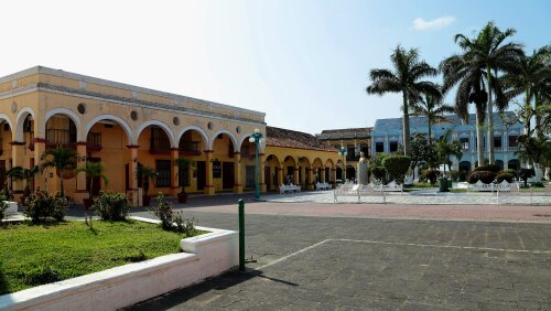
Info about Tlacotalpan, Estado de Veracruz-Llave (Mexico)
Tlacotalpan region is Estado de Veracruz-Llave, in Mexico (MX).
Tlacotalpan is also called Tlacotalpan, latitude is 18.6133300, and its longitude is -95.6589000.
In Tlacotalpan there are 7.600 folks, this city timezone is America/Mexico_City (America/Mexico_City_cet).
Tlacotalpan is a popular travel destination for festival, countryside, events in all Mexico.
.
More details about Tlacotalpan in Mexico (MX)
It is the capital of Tlacotalpan Municipality.
Do You are looking to use telephone for calling local people. Use 288 if you wish to call local phone numbers. It’s postal code is 95460, so for post delivery it can be used the code as per description.
Tlacotalpan square area is 75 square kilometers, so Tlacotalpan is a medium size city that can become, if it is not already, a boomtown, definitely a place worth visiting. If you stay here you save money because of its cheap room costs, and for this reason you could use it like your base to move across Mexico or Tlacotalpan near places.
Its altitude above mean sea level, basically meters above sea level (MASL), is about 10 mt. Because of this Tlacotalpan is an ideal travel destination if you and friends want to be near the sea.
For information about Tlacotalpan go to its official webpage http://www.tlacotalpan-turismo.gob.mx/.
Tlacotalpan is designated as World Heritage classified by UNESCO, starting from +1998.
Tlacotalpan things to do and activities: best trip destination for:
Interactive Tlacotalpan (Mexico) Map and attractions
Interactive map of Tlacotalpan, Estado de Veracruz-Llave Mexico (MX).
